Event Info » Course map and description » History of the communities en route
History of the communities en route
Summarized from articles on the Sunshine Coast Museum & Archives website.
We thought you might like to learn a little about the areas you will be running through.
Gibsons
The first people of the area were the Squamish Nation (or S?wxwú7mesh in the Squamish language) who inhabited a seasonal fishing village north of Gibsons Landing named Chek-welp. The Chek-welp villagers also used the Gibsons Landing area as a lookout, which provided advance notice of invaders visible through the West Howe Sound gap. Several successive outbreaks of small pox led to the eventual abandonment of the Chek-welp village in the early 1900s.
The first European settler to the Gibsons area (almost one hundred years after initial exploration by the Spanish) was George Gibson, an ex-British naval officer born in 1829. He met his wife Charlotte in Ontario; they later moved to BC. After a short stay in Vancouver, George and his sons travelled to Howe Sound in 1886. George Gibson was fifty-eight years old at this time but had the energy and vision to not only build his own homestead but encourage other settlers to come and live around him and form a community. Within two years, Gibson had built a two-storey house, planted 100 fruit trees and cultivated four acres of his land, enough to ship his produce to Vancouver to sell. He was very active in the community that developed, generously donating land for the school and church. He also acted as postmaster in the early years and was a jovial host to any visitors that might tie up at his wharf. The name Gibson's Landing was adopted in 1906 as the official postal address. George passed away July 11th, 1913 but he and his family are still celebrated every year during George & Charlotte Gibson Day.
The area grew so fast, it was necessary to build a temporary log-cabin school in 1889. The following year, a school district was organized and a permanent school was constructed on the present site of Gibsons Elementary. The first classes were held on January 19, 1891 with teacher Mrs. Lucy Smith presiding over her 23 students.
Until after World War II, Gibsons and area remained a small rural community based on Logging, Fishing and a limited amount of agriculture. In 1951 a car ferry service, Black Ball Ferries, later to become BC Ferries, was started, and for the first time it became relatively easy to travel between Gibsons and the Lower Mainland by car. In the next few years, the roads between the various communities on the Sunshine Coast were paved and improved which encouraged commerce between these areas as well as with Vancouver.
At this point, growth became much more rapid. A new high school was constructed at Gibsons, and shortly after, the area's first Supermarket. Both of these buildings were located on the flat land at the top of the hillside, an area that was part of the old farming district where flat land allowed expansion and adequate parking compared to the old business area around the wharf at the waterfront. This trend in development continued, and now today most commercial activity is located in "Upper Gibsons" while the waterfront has become more of a tourist and cultural area.
Roberts Creek
The Roberts Creek area was originally occupied by natives of the Coast Salish nation, specifically the shishalh tribe, from which the town of Sechelt took its name. The shishalh people referred to Roberts Creek as hwah-sam, meaning big, fat salmon.
European exploration of the area began in the late 1700s by the Spanish (Captain Galiano and Captain Valdes) and the British (Captain Vancouver). The earliest non-Native observation of the Roberts Creek area was recorded by Captain Vancouver.
Roberts Creek's present name came from the first European settler to this area, Thomas William "Will" Roberts. In 1889, he staked out a quarter section of flat land just east of the creek. To earn his crown grant to the claim, he built two cedar shake cabins, a chicken house and stables and cleared three acres for cultivation and fruit trees. Will's mother and father, Thomas & Charlotte Roberts, arrived from England the following year and Will's brother, John Francis "Frank" Roberts, joined the family two years later. Frank built a large log house a quarter mile east of the creek for his parents.
Another brother, Harry Roberts was one of the most influential of the early Creek settlers. Formerly a painter, author and philosopher in England, he brought his visionary spirit to the Sunshine Coast. A multi-talented entrepreneur, he catered to summer travellers and local farmers by building a store near the mouth of the creek (near the current site of the Roberts Creek General Store). He also built a sawmill which provided lumber for most of the new houses in the area and for the government wharf, and timbers for the 13 bridges necessary to construct Lower Road.
Harry also originated the term Sunshine Coast. He painted a huge sign, visible from the ocean, on the side of the steamer company's freight shed near his store proclaiming this area as the Sunshine Belt, later modified to the Sunshine Coast.
Sechelt
The first self-governing First Nation (1986) in Canada, the Shishahl, known today as the Sechelt Nation, have lived on the Sunshine Coast for thousands of years. Their history and present day culture is displayed in the Sechelt First Nation's museum, tems swiya, in Sechelt and is visible in protected petroglyphs, pictographs and middens along the Sunshine Coast's shorelines. After the Europeans came to the area, the Band members left their many villages scattered throughout the Sunshine Coast, Sechelt Inlet and Jervis Inlet to settle in Sechelt.
Note: The Spanish were the first Europeans to sail along our coast in 1791 — they even went ashore near Mission Point in Davis Bay (our finish line and post-race festivities will be in Mission Point Park on this very spot!).
In 1875 the first legal survey of today's Sechelt was conducted by Captain William S. Jemmett. Sapper John Scales, a member of the Royal Engineers, had applied for his 150-acre free military grant in 1869 located on the southern most part of today's Sechelt. It wasn't until 1891 that he actually received the grant plus an additional 110 acres, today's northerly part of Sechelt, for which he paid $110. Shortly after receiving legal title to these lands he sold them to the Honourable Hugh Nelson, fourth Lieutenant Governor of British Columbia, whose widow in turn sold them to recent English immigrants Alfred Whitaker and his son Herbert in 1895.
As early as 1892 Herbert Whitaker and his father Alfred had seen the potential for Sechelt as a resort and a resource for lumber and fish. After Alfred and Herbert acquired what is today's Sechelt Herbert built two hotels, a series of stores, two wharves, one at Trail Bay the other on Porpoise Bay in Sechelt Inlet, and a group of revenue cottages. He also owned two sawmills, five logging camps and a steamship company, all in the space of twenty years. One of his revenue cottages still stands on Sechelt's Boulevard. His brothers were also involved in the development of the Sunshine Coast at Davis Bay and Gibsons.
As access to Sechelt and the Sunshine Coast was by water, Herbert Whitaker started the Sechelt Steamship Company to bring tourists to his hotels and cottages, supplies to his stores and workers to his logging operations. Other pioneer settlers came either to work for Herbert or to establish their own farms, logging or fishing businesses and stores. Many of their descendants continue to live on the Sunshine Coast.
Highway 101 was completed in 1952 linking the ferry terminal in Langdale to the ferry terminal in Earl's Cove.
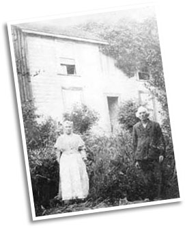
George and Charlotte Gibson in the garden of their home, 1904. Photo from Sunshine Coast Museum & Archives.